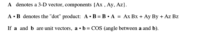
James Miller G3RUH
In time the program accumulated several other modules, with the mathematics described in interim O.N. articles. When issued for the BBC micro the program acquired the name "PLAN10", and later "PLAN13", and it's been transcribed for several other machines including the IBM-PC and Commodore 64 etc.
In recent years or so my mail has featured more and more queries about tracking matters than was usual. The flavour of these suggests that a new generation of satellite enthusiasts is emerging and are rightly asking the old questions anew.
So for a long while I've been intending to re-publish these routines, but in their most up-to-date embodiment. Hence this pamphlet. I don't intend to provide 100% mathematical details. To do so means essentially writing the whole program out anyway, and references are plentiful.
Old hands will recognise the coding style. Additions include the Sun's position, eclipses, visibility, Sun angle, sub-satellite point, mode switching, date algorithms and direct range-rate calculations for doppler shift.
Almost every publication to do with satellites has information about orbits and their properties. For general reading The Satellite Experimenter's Handbook [2] is unsurpassed, and itself documents several hundred references. Fundamentals of Astrodynamics [3] is a no-nonsense text that's full of insights, and is incredibly cheap.
Models for the Propagation of NORAD Element Sets [4] documents five ways to use a set of keps properly. SGP, the simplest model, runs to 4 pages of higher mathematics just to compute satellite position and velocity. All amateur implementations (i.e. lines 2000-2210 of PROCsatvec) use only the first half page of this, skipping the long term perturbatory effects. Sun's Up [5] is about modelling the Sun's position, and describes applications including illumination and eclipses. 30.6 days Hath September [6] documents date algorithms. The Astronomical Almanac [7] is invaluable for checking calculations; an annual, but useful for many years.
Surprisingly when OSCAR10.BAS was published there were complaints that "filling Oscar News with programs was a waste of space" etc etc. My reply to this myopic view was, and remains:
"The program was designed to be more than a mere listing to be blindly typed in and run. It is a treatise giving all the equations for solving the elliptic orbit and related problems. To do this, as well as provide a tool suitable for immediate use the program was written in a quasi-algebraic style. Variable names were chosen to be meaningful, there are copious comments, and routines are written so that users can adapt them as they wish. However the published arrangement is not the only one. The program is a clear formulation of the general satellite orbit problem, and is sure to provide the interested amateur with several months of absorbing self-training material". Plunder! Enjoy!
2. Davidoff M.R., Satellite Experimenter's Handbook, 2nd edition, ARRL 1990. ISBN 0-87259-004-6.
3. Bate R., Mueller D. & White J., Fundamentals of Astrodynamics, Dover 1971. ISBN 0-486-60061-0.
4. Hoots F.R. & Roerich R.L., Models for Propagation of NORAD Element Sets, USAF Spacetrack Report No.3, 1988 December.
5. Miller J.R., Sun's Up Part 1, Oscar News, 1984 Dec, No.50 p.2-6; Part 2, 1985 Feb, No.51 p.2-6; "Part 3", 1985 Apr, No.52 p.8-11.
6. Miller J.R., 30.6 days hath September, Oscar News, 1985 Dec, No.56 p.6-9.
7. The Astronomical Almanac 1984, Section C, TSO and USGPO. ISBN 0-11-886919-1
PLAN13 v2.0   SATELLITE PREDICTIONS
-----------------------------------
Enter start date (e.g. 1990, 12, 25) ? 1990,11,3
Enter number of days for printout    ? 1

OSCAR-13  -  G3RUH                AMSAT DAY 4689            1990 Nov 3 [Sat]
ORBIT: 1828   AP/RAAN: 239/128   ALON/ALAT: 180/0   SAZ/SEL: 210/-72   ILL: 96%

 UTC  MA  MODE  RANGE     EL     AZ     SQ     RR  ECL?    HGT    SLAT   SLON
-----------------------------------------------------------------------------
0100  38   B    25929      3     89     48    2.1   vis   20635     13     80
0115  43   B    27716      8     87     43    1.9   vis   22880     17     79
0130  49   B    29345     12     86     38    1.7   vis   24917     21     78
0145  55   B    30825     16     85     34    1.6   vis   26763     24     77
0200  60   B    32160     20     84     30    1.4   vis   28432     26     75
 etc
Amsat day numbers are reckoned from 0 = 1978 Jan 01; AP is argument of perigee; ALON/ALAT are the satellite's attitude; SAZ/SEL are Sun's position in the orbit plane, and ILL is solar panel illumination. MA is mean anomaly in units of 256 per orbit. SQ is squint angle, RR is range rate (km/s), ECL? will indicate if the satellite is in eclipse, or whether it is potentially visible. HGT is height (km), and SLAT SLON are sub-satellite latitude and longitude (deg East).
PROCinit (lines 1000-1840): All the constants needed by the routines are established here. Most relate to a physical quantity, but are then combined with others or need units changing to form a derived quantity. Some of these constants are only used transiently within "init" itself, but are included for clarity.
PROCsatvec (lines 2000-2430): Takes input variables day (DN) and fraction of day (TN) and computes satellite position, velocity and antenna direction in orbit plane coordinates. These are then output in celestial coordinates and geocentric coordinates.
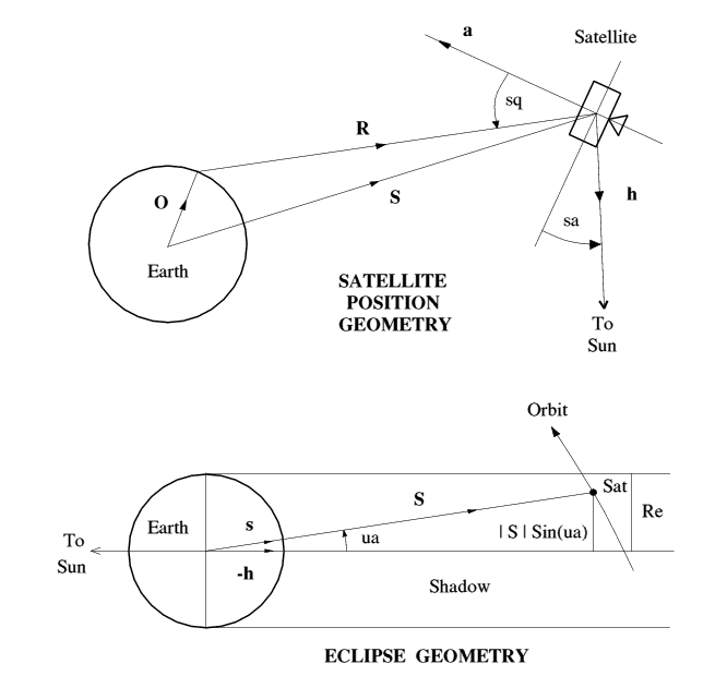
PROCrangevec (lines 4000-4200): Calculates Range vector from satellite and observer vector, and derives range, azimuth, elevation, squint, range rate and sub-satellite point.
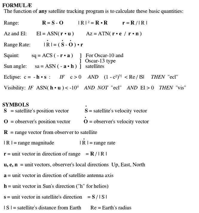
PROCsunvec (lines 3000-3260): Computes Sun's position in celestial coordinates, and then Sun angle, illumination, visibility and eclipse details. Actual visibility also depends on brightness of satellite, and darkness of sky.
FNday(Y,M,D) Function returns a general day number from year, month and day. Value is Julian Day - 1721409.5 or Amsat day + 722100
FNdate(DN) Function converts day number to a string, e.g. 1990 Nov 3 [Sat]
FNatn(Y,X) Crash-proof four quadrant arctangent. Returns value in range 0-2pi
 BBC BASIC                   Effect         OTHER BASICS
 ---------------------------------------------------------------------
 PROCname .... ENDPROC     subroutine       GOSUB nnnn ....  RETURN
 DEG(X)                    rad -> deg       X*180/PI  )  where PI =
 RAD(X)                    deg -> rad       X*PI/180  )  3.141592654
 ASN(X)                    arcsin           FNatn(X,SQR(1-X*X))
 ACS(X)                    arccos           PI/2 - FNatn(X,SQR(1-X*X))
 ---------------------------------------------------------------------
   10 T$="PLAN13": REM   OSCAR-13 POSITION, SUN + ECLIPSE PLANNER
   20 REM
   30 IS$="v2.0": REM Last modified 1990 Aug 12 by JRM
   40 REM
   50 REM           (C)1990 J.R. Miller G3RUH
   60 REM
   70 REM Proceeds from the sale of this software go directly to the
   80 REM Amateur Satellite Programme that helped fund AO-13.
   90 REM If you take a copy PLEASE also send a small donation to:
  100 REM           AMSAT-UK, LONDON, E12 5EQ.
  110
  120 MODE 3:    REM Screen 80 columns
  130 PROCinit:  REM Set up constants
  140
  150 INPUT "Enter start date (e.g. 1990, 12, 25) ";YR,MN,DY
  160 INPUT "Enter number of days for printout    ";ND
  170 DS = FNday(YR,MN,DY):     REM Start  day No.
  180 DF = DS + ND - 1:         REM Finish day No.
  190   FOR DN = DS TO DF
  200     FOR HR  = 0 TO 23
  210       FOR MIN = 0 TO 45 STEP 15
  220         TN = (HR+MIN/60)/24
  230         PROCsatvec
  240         PROCrangevec
  250         PROCsunvec
  260         IF EL > 0 THEN PROCprintdata
  270 NEXT:NEXT:NEXT
  280 END

 1000 DEF PROCinit
 1010 REM SATELLITE EPHEMERIS
 1020 REM -------------------
 1030 SAT$="OSCAR-13"
 1040 YE = 1990      : REM Epoch Year    year
 1050 TE = 191.145409: REM Epoch time    days
 1060 IN =  56.9975  : REM Inclination   deg
 1070 RA = 146.4527  : REM R.A.A.N.      deg
 1080 EC = 0.6986    : REM Eccentricity   -
 1090 WP = 231.0027  : REM Arg perigee   deg
 1100 MA =  43.2637  : REM Mean anomaly  deg
 1110 MM = 2.09695848: REM Mean motion   rev/d
 1120 M2 = 1E-8      : REM Decay Rate    rev/d/d
 1130 RV = 1585      : REM Orbit number   -
 1140 ALON = 180     : REM Sat attitude, deg. 180 = nominal ) See bulletins
 1150 ALAT =   0     : REM Sat attitude, deg.   0 = nominal ) for latest
 1160
 1170 REM Observer's location + North, + East, ASL(m)
 1180 LOC$="G3RUH": LA = 52.21: LO = 0.06: HT = 79:  REM Cambridge, UK
 1190
 1200 LA = RAD(LA): LO = RAD(LO): HT = HT/1000
 1210 CL = COS(LA): SL = SIN(LA): CO = COS(LO): SO = SIN(LO)
 1220 RE = 6378.137: FL = 1/298.257224:  REM WGS-84 Earth ellipsoid
 1230 RP = RE*(1-FL): XX = RE*RE: ZZ = RP*RP
 1240 D  = SQR(XX*CL*CL + ZZ*SL*SL)
 1250 Rx = XX/D + HT: Rz = ZZ/D + HT
 1260
 1270 REM Observer's unit vectors UP EAST and NORTH in GEOCENTRIC coords.
 1280 Ux =CL*CO: Ex =-SO: Nx =-SL*CO
 1290 Uy =CL*SO: Ey = CO: Ny =-SL*SO
 1300 Uz =SL   : Ez =  0: Nz = CL
 1310
 1320 REM Observer's XYZ coords at Earth's surface
 1330 Ox = Rx*Ux: Oy = Rx*Uy: Oz = Rz*Uz
 1340
 1350 REM Convert angles to radians etc.
 1360 RA = RAD(RA): IN = RAD(IN): WP = RAD(WP)
 1370 MA = RAD(MA): MM = MM*2*PI: M2 = M2*2*PI
 1380
 1390 YM = 365.25:      REM Mean Year,     days
 1400 YT = 365.2421874: REM Tropical year, days
 1410 WW = 2*PI/YT:     REM Earth's rotation rate, rads/whole day
 1420 WE = 2*PI + WW:   REM       ditto            radians/day
 1430 W0 = WE/86400:    REM       ditto            radians/sec
 1440
 1450 VOx=-Oy*W0: VOy=Ox*W0: REM Observer's velocity, GEOCENTRIC coords. (VOz=0)
 1460
 1470 REM Convert satellite Epoch to Day No. and Fraction of day
 1480 DE = FNday(YE,1,0)+INT(TE): TE = TE-INT(TE)
 1490
 1500 REM Average Precession rates
 1510 GM = 3.986E5:       REM Earth's Gravitational constant km^3/s^2
 1520 J2 = 1.08263E-3:    REM 2nd Zonal coeff, Earth's Gravity Field
 1530 N0 = MM/86400:      REM Mean motion rad/s
 1540 A0 = (GM/N0/N0)^(1/3):  REM Semi major axis km
 1550 B0 = A0*SQR(1-EC*EC):   REM Semi minor axis km
 1560 SI = SIN(IN): CI = COS(IN)
 1570 PC = RE*A0/(B0*B0): PC = 1.5*J2*PC*PC*MM: REM Precession const, rad/Day
 1580 QD = -PC*CI:            REM Node precession rate, rad/day
 1590 WD =  PC*(5*CI*CI-1)/2: REM Perigee precession rate, rad/day
 1600 DC = -2*M2/MM/3: REM Drag coeff. (Angular momentum rate)/(Ang mom)  s^-1
 1610
 1615 REM *** Please see end of listing for newer values; use old ones for test. ***
 1617
 1620 REM Sidereal and Solar data. Rarely needs changing. Valid to year ~2015
 1630 YG = 2000: G0 = 98.9821:  REM GHAA, Year YG, Jan 0.0
 1640 MAS0 = 356.0507: MASD = 0.98560028: REM MA Sun and rate, deg, deg/day
 1650 INS = RAD(23.4393): CNS = COS(INS): SNS = SIN(INS): REM Sun's inclination
 1660 EQC1=0.03342: EQC2=0.00035:   REM Sun's Equation of centre terms
 1670
 1680 REM Bring Sun data to Satellite Epoch
 1690 TEG  = (DE-FNday(YG,1,0)) + TE: REM Elapsed Time: Epoch - YG
 1700 GHAE = RAD(G0) + TEG*WE:        REM GHA Aries, epoch
 1710 MRSE = RAD(G0) + TEG*WW + PI:   REM Mean RA Sun at Sat epoch
 1720 MASE = RAD(MAS0 + MASD*TEG):    REM Mean MA Sun  ..
 1730
 1740 REM Antenna unit vector in orbit plane coordinates.
 1750 CO=COS(RAD(ALON)): SO=SIN(RAD(ALON))
 1760 CL=COS(RAD(ALAT)): SL=SIN(RAD(ALAT))
 1770 ax = -CL*CO: ay = -CL*SO: az = -SL
 1780
 1790 REM Miscellaneous
 1800 @%=&507: REM 5 decimals, field 7
 1810 OLDRN=-99999
 1820 PRINT T$;" ";IS$;"   SATELLITE PREDICTIONS"
 1830 PRINT STRING$(35,"-")
 1840 ENDPROC

 2000 DEF PROCsatvec
 2010 REM Calculate Satellite Position at DN,TN
 2020 T  = (DN - DE) + (TN-TE):REM Elapsed T since epoch, days
 2030 DT = DC*T/2: KD = 1+4*DT:KDP= 1-7*DT: REM Linear drag terms
 2040 M  = MA + MM*T*(1-3*DT): REM Mean anomaly at YR,TN
 2050 DR = INT(M/(2*PI)):      REM Strip out whole no of revs
 2060 M  = M - DR*2*PI:        REM M now in range 0 - 2pi
 2070 RN = RV + DR:            REM Current Orbit number
 2080
 2090 REM Solve M = EA - EC*SIN(EA) for EA given M, by Newton's Method
 2100 EA = M:                 REM Initial solution
 2110 REPEAT
 2120   C = COS(EA): S = SIN(EA): DNOM=1-EC*C
 2130   D = (EA-EC*S-M)/DNOM:   REM Change to EA for better solution
 2140   EA = EA - D:            REM by this amount
 2150 UNTIL ABS(D) < 1E-5:      REM Until converged
 2160
 2170 A = A0*KD: B = B0*KD: RS = A*DNOM: REM Distances
 2180
 2190 REM Calc satellite position & velocity in plane of ellipse
 2200 Sx = A*(C-EC): Vx=-A*S/DNOM*N0
 2210 Sy = B*S:      Vy= B*C/DNOM*N0
 2220
 2230 AP   = WP + WD*T*KDP: CW = COS(AP):   SW = SIN(AP)
 2240 RAAN = RA + QD*T*KDP: CQ = COS(RAAN): SQ = SIN(RAAN)
 2250
 2260 REM Plane -> celestial coordinate transformation, [C] = [RAAN]*[IN]*[AP]
 2270 CXx=CW*CQ-SW*CI*SQ: CXy=-SW*CQ-CW*CI*SQ: CXz= SI*SQ
 2280 CYx=CW*SQ+SW*CI*CQ: CYy=-SW*SQ+CW*CI*CQ: CYz=-SI*CQ
 2290 CZx=SW*SI:          CZy= CW*SI:          CZz= CI
 2300
 2310 REM Compute SATellite's position vector, ANTenna axis unit vector
 2320 REM and VELocity in CELESTIAL coordinates. (Note: Sz=0, Vz=0)
 2330 SATx=Sx*CXx+Sy*CXy: ANTx=ax*CXx+ay*CXy+az*CXz: VELx=Vx*CXx+Vy*CXy
 2340 SATy=Sx*CYx+Sy*CYy: ANTy=ax*CYx+ay*CYy+az*CYz: VELy=Vx*CYx+Vy*CYy
 2350 SATz=Sx*CZx+Sy*CZy: ANTz=ax*CZx+ay*CZy+az*CZz: VELz=Vx*CZx+Vy*CZy
 2360
 2370 REM Also express SAT,ANT and VEL in GEOCENTRIC coordinates:
 2380 GHAA = GHAE + WE*T:           REM GHA Aries at elapsed time T
 2390 C = COS(-GHAA): S = SIN(-GHAA)
 2400 Sx=SATx*C - SATy*S: Ax=ANTx*C - ANTy*S: Vx=VELx*C - VELy*S
 2410 Sy=SATx*S + SATy*C: Ay=ANTx*S + ANTy*C: Vy=VELx*S + VELy*C
 2420 Sz=SATz:            Az=ANTz:            Vz=VELz
 2430 ENDPROC

 3000 DEF PROCsunvec
 3010 MAS = MASE + RAD(MASD*T):       REM MA of Sun round its orbit
 3020 TAS = MRSE + WW*T + EQC1*SIN(MAS) + EQC2*SIN(2*MAS)
 3030 C = COS(TAS): S=SIN(TAS):       REM Sin/Cos Sun's true anomaly
 3040 SUNx=C: SUNy=S*CNS: SUNz=S*SNS: REM Sun unit vector - CELESTIAL coords
 3050
 3060 REM Find Solar angle, illumination, and eclipse status.
 3070 SSA = -(ANTx*SUNx + ANTy*SUNy + ANTz*SUNz):REM Sin of Sun angle -a.h
 3080 ILL = SQR(1-SSA*SSA):                      REM Illumination
 3090 CUA = -(SATx*SUNx+SATy*SUNy+SATz*SUNz)/RS: REM Cos of umbral angle -h.s
 3100 UMD = RS*SQR(1-CUA*CUA)/RE:                REM Umbral dist, Earth radii
 3110 IF CUA>=0 THEN ECL$="    +" ELSE ECL$="    -": REM + for shadow side
 3120 IF UMD <= 1 AND CUA>=0 THEN ECL$="   ECL":     REM - for sunny side
 3130
 3140 REM Obtain SUN unit vector in GEOCENTRIC coordinates
 3150 C = COS(-GHAA): S = SIN(-GHAA)
 3160 Hx=SUNx*C - SUNy*S
 3170 Hy=SUNx*S + SUNy*C:  REM If Sun more than 10 deg below horizon
 3180 Hz=SUNz:             REM satellite possibly visible
 3190 IF (Hx*Ux+Hy*Uy+Hz*Uz < -0.17) AND (ECL$ <> "   ECL") THEN ECL$="   vis"
 3200
 3210 REM Obtain Sun unit vector in ORBIT coordinates
 3220 Hx =  SUNx*CXx + SUNy*CYx + SUNz*CZx
 3230 Hy =  SUNx*CXy + SUNy*CYy + SUNz*CZy
 3240 Hz =  SUNx*CXz + SUNy*CYz + SUNz*CZz
 3250 SEL = ASN(Hz): SAZ= FNatn(Hy,Hx)
 3260 ENDPROC

 4000 DEF PROCrangevec
 4010 REM Compute and manipulate range/velocity/antenna vectors
 4020 Rx = Sx-Ox: Ry = Sy-Oy: Rz = Sz-Oz: REM Rangevec = Satvec - Obsvec
 4030 R = SQR(Rx*Rx+Ry*Ry+Rz*Rz):         REM Range magnitude
 4040 Rx=Rx/R: Ry=Ry/R: Rz=Rz/R: REM Normalise Range vector
 4050 U = Rx*Ux+Ry*Uy+Rz*Uz:     REM UP    Component of unit range
 4060 E = Rx*Ex+Ry*Ey:           REM EAST    do   (Ez=0)
 4070 N = Rx*Nx+Ry*Ny+Rz*Nz:     REM NORTH   do
 4080 AZ = DEG(FNatn(E,N)):      REM Azimuth
 4090 EL = DEG(ASN(U)):          REM Elevation
 4100
 4110 REM Resolve antenna vector along unit range vector, -r.a = Cos(SQ)
 4120 SQ = DEG(ACS(-(Ax*Rx + Ay*Ry + Az*Rz))): REM Hi-gain ant SQuint
 4130
 4140 REM Calculate sub-satellite Lat/Lon
 4150 SLON = DEG(FNatn(Sy,Sx)):  REM Lon, + East
 4160 SLAT = DEG(ASN(Sz/RS)):    REM Lat, + North
 4170
 4180 REM Resolve Sat-Obs velocity vector along unit range vector. (VOz=0)
 4190 RR  = (Vx-VOx)*Rx + (Vy-VOy)*Ry + Vz*Rz:  REM Range rate, km/s
 4200 ENDPROC

 4220 DEF FNatn(Y,X)
 4230 IF X <> 0 THEN A=ATN(Y/X) ELSE A=PI/2*SGN(Y)
 4240 IF X < 0 THEN A=A+PI
 4250 IF A < 0 THEN A=A+2*PI
 4260 =A

 4280 DEF PROCmode
 4290 M=INT(M*128/PI)
 4300 REM Mode switching MA/256
 4310 MD$="-"
 4320 IF M >=   0 THEN MD$="B"
 4330 IF M >= 100 THEN MD$="L"
 4340 IF M >= 130 THEN MD$="S"
 4350 IF M >= 135 THEN MD$="B"
 4360 IF M >= 220 THEN MD$="-"
 4370 ENDPROC

 5000 DEF FNdate(D)
 5010 REM Convert day-number to date; valid 1900 Mar 01 - 2100 Feb 28
 5020 D=D+428: DW=(D+5)MOD7
 5030 Y=INT((D-122.1)/YM): D=D-INT(Y*YM)
 5040 MN=INT(D/30.61): D=D-INT(MN*30.6)
 5050 MN=MN-1: IF MN>12 THEN MN=MN-12: Y=Y+1
 5060 D$=STR$(Y)+" "+MID$("JanFebMarAprMayJunJulAugSepOctNovDec",3*MN-2,3)
 5070 =D$+" "+STR$(D)+" ["+MID$("SunMonTueWedThuFriSat",3*DW+1,3)+"]"
 5080
 5090 DEF FNday(Y,M,D)
 5100 REM Convert date to day-number
 5110 IF M<=2 THEN Y=Y-1: M=M+12
 5120 =INT(Y*YM) + INT((M+1)*30.6) + D-428

 6000 DEF PROCprintdata
 6010 REM Construct time as a string
 6020 HR$=STR$(HR): MIN$=STR$(MIN)
 6030 IF LEN(HR$)  < 2 THEN HR$="0"+HR$
 6040 IF LEN(MIN$) < 2 THEN MIN$="0"+MIN$
 6050 TIM$=HR$+MIN$+"  "
 6060
 6070 PROCmode:  REM Get AO-13 mode.  Now round-off data
 6080 R=FNrn(R): EL=FNrn(EL): AZ=FNrn(AZ): SQ=FNrn(SQ): RR=FNrn(RR*10)/10
 6090 HGT=FNrn(RS-RE): SLON=FNrn(SLON): SLAT=FNrn(SLAT)
 6100 IF RN <> OLDRN THEN OLDRN=RN: PROCheader
 6110 PRINT TIM$;STR$(M);"   ";MD$,R,EL,AZ,SQ,RR,ECL$,HGT,SLAT,SLON
 6120 ENDPROC
 6130
 6140 DEF PROCheader
 6150 RAAN=FNrn(DEG(RAAN)): AP=FNrn(DEG(AP)): SAZ=FNrn(DEG(SAZ))
 6160 SEL=FNrn(DEG(SEL)): ILL=FNrn(100*ILL)
 6170 PRINT: PRINT
 6180 PRINT SAT$;"  -  "LOC$;SPC(16);"AMSAT DAY ";STR$(DN-722100);SPC(12);FNdate(DN)
 6190 PRINT "ORBIT: ";RN;"   AP/RAAN: ";AP;"/";RAAN;"   ALON/ALAT:";ALON;"/";ALAT;
 6200 PRINT"   SAZ/SEL: ";SAZ;"/";SEL;"   ILL: ";ILL;"%"
 6210 PRINT
 6220 PRINT " UTC  MA  MODE  RANGE     EL     AZ     SQ     RR  ECL?    ";
 6230 PRINT "HGT    SLAT   SLON"
 6240 PRINT STRING$(77,"-")
 6250 ENDPROC
 6260
 6270 DEF FNrn(X) = INT(X+0.5)

*** Astronomical data for 2023 onwards

�1620�REM�Sidereal�and�Solar�data.
�1630�YG�=�2023:�G0�=�99.4057:��REM�GHAA,�Year�YG,�Jan�0.0
�1640�MAS0�=�356.0787:�MASD�=�0.98560028:�REM�MA�Sun�and�rate,�deg,�deg/day
�1650�INS�=�RAD(23.4363):�CNS�=�COS(INS):�SNS�=�SIN(INS):�REM�Sun's�inclination
�1660�EQC1=0.03340:�EQC2=0.00035:���REM�Sun's�Equation�of�centre�terms

***
In earlier versions of the program, the conversion of a vector from Orbit plane coordinates to Celestial coordinates was written out stage by stage. That is, a rotation in argument of perigee, followed by a rotation through inclination, and finally through RAAN. Since there are actually several vectors (satellite position, velocity and antenna axis) to transform, this became a little clumsy, so the three rotations are now amalgamated into one. The array [C] that does this is computed at lines 2260-2290.
Celestial -> Orbit Plane Coordinate Transformation
The array [C] can also be used in the reverse direction, to convert a vector from Celestial to Orbit plane coordinates. This is done by "transposing the array", using C(J,I) for C(I,J) throughout. This is used to calculate the Sun's position as seen from the orbit plane (lines 3210-3240).
Decay
The Keplerian element DECAY is half the rate of change of mean motion. DECAY is usually very small, of order 10^-7, and its short term influence is small. For example, MA is affected by an amount DECAY*T*T over T days. Over 100 days that makes 10^-7*100*100 = 0.001 revolutions, or about 7.2 seconds for a 2 hour period satellite.
Decay is only really significant for low altitude satellites such as the space shuttle, ISS, or satellites nearing burn-up. Then the value can be as large as 10^-4. This causes in addition a noticeable second order effect on semi-major axis, argument of perigee and RAAN. The program accounts for this with terms calculated at line 2030.
For many purposes, especially if the Keplerian elements are regularly updated, drag can be ignored. This is true in particular for Oscar-13, where the unmodelled luni-solar perturbations are substantially larger than "decay".
Doppler Shift
The program calculates range-rate RR (line 4190) in km/s. If a satellite transmits a frequency FT, then this is received as a frequency FR:
FR = FT * (1 - RR/299792). [Note: 299792 is the speed of light in km/s]
Thus the "doppler shift" FD is given by: FD = -FT*RR/299792.
The calculation of range-rate is accurate in vacuo. However, at low elevations the radio path through the Earth's atmosphere is not perfectly straight. This refraction causes the actual observed doppler shift at AOS and LOS to be as much as 1 part in 10^7 in error, say 50-100 Hz at 435 MHz. It should also be noted that simple crystal oscillators have a similar order of stability, and satellites usually experience large temperature changes.
Footprint
In some programs there is a requirement to draw a circle around the sub- satellite point to indicate the field of view of the satellite. The following routine indicates how to do this. It is coded for clarity, not for speed. It would be better to store SIN(A) and COS(A) in a table rather than compute them every call. Since the footprint is left-right symmetric, only one half of the circle's points need be computed, and the other half can be inferred logically.
The sub-routine's output is a unit vector {X,Y,Z} in geocentric coordinates for the I'th point on the Earth's surface. This will then need transforming to map coordinates (mercator, spherical, linear or whatever), and then screen coordinates to suit the computer.
DEF PROCfoot(RS, slat, slon)
REM Take satellite distance, sub-satellite lat/lon and compute unit vectors'
REM x,y,z of N points of footprint on Earth's surface in Geocentric
REM Coordinates.  Also terrestrial latitude and longitude of points.
:
srad = ACS(RE/RS):                 REM Radius of footprint circle
cla = COS(slat): sla = SIN(slat):  REM Sin/Cos these to save time
clo = COS(slon): slo = SIN(slon)
sra = SIN(srad): cra = COS(srad)
FOR I = 0 TO N:      REM N points to the circle
A = 2*PI*I/N:        REM Angle around the circle
:
X = cra:             REM Circle of points centred on Lat=0, Lon=0
Y = sra*SIN(A):      REM assuming Earth's radius = 1
Z = sra*COS(A)       REM [ However, use a table for SIN(.)  COS(.) ]
:
x = X*cla - Z*sla:   REM Rotate point "up" by latitude  slat
y = Y
z = X*sla + Z*cla
:
X = x*clo - y*slo:   REM Rotate point "around" through longitude  slon
Y = x*slo + y*clo
Z = z
:
LON(I) = FNatn(Y,X): REM Convert point to Lat/Lon (or as required by map
LAT(I) = ASN(Z):     REM projection and display system).
NEXT I
ENDPROC
Squint Angle
Squint (or pointing) angle is the angle between the spacecraft's antenna and the observer. This is calculated at line 4120 for Oscar-13's high-gain antennas. As the low gain antennas are simple monopoles radiating normal to the a axis, low-gain squint is given by:
SQ_low_gain = 90 - SQ_high_gain (deg)Some satellites are stabilised so that they are continuously Earth pointing (e. g. UOSATs). For these, the antenna axis unit vector is aligned with the spacecraft's position vector, i.e. a = -s So to calculate the squint angle for these satellites use the formula:
4120 SQ = DEG(ACS( (Sx*Rx + Sy*Ry + SZ*Rz)/RS )) (deg)Sun Model and Sidereal Constants
The calculations of Earth rotation and Sun position are the most accurate part of this program! There is no need to update the solar constants at lines 1630-1660 for several decades.
This program was written and evolved over a period of years from 1983 to 1990. Constructive comment and suggestions are welcome.
Feedback on these pages to Webmaster. Feedback on the article should be sent to James Miller
Created: 1994 Dec 09 -- Last modified: 2023 Apr 12